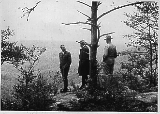
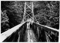
Visitors to the Gulf enjoy the view from Yellow Bluff Overlook, circa 1966.
"There are few places in the Upper Cumberlands that are not special
to someone. There are even fewer places that are special to everyone.
Scott's Gulf is one of those places."
[ Entrance ][ Scott's Gulf Home ][ Scott's Gulf Virtual Tour ][ Scott's Gulf Today ]
[ Scott's Gulf FAQs ][ Friends of Scott's Gulf ][ Archives ]
Visitors to the Gulf enjoy the view from Yellow Bluff Overlook, circa 1966.
History of Scott's Gulf
Scott's Gulf, located just south and east of Sparta, Tennessee, and south and west of Crossville, Tennessee, is the beautiful, scenic canyon containing the most rugged and pristine sections of the Caney Fork River, a major tributary of the Cumberland River. Flowing rapidly down from the Cumberland Plateau, the river descends in a series of falls, rapids, caves and canyons that stretch for 18 miles between the Clifty Bridge and Big Bottom Cove. The river loses a total of 568 feet of elevation between the Clifty Bridge and Dodson Bridge in Big Bottom.
Travelling down the Chicamauga Path and the Black Fox Trail, early settlers began trickling into the area in the late 1700s. Frequently, they found themselves at odds with the local Native Americans, primarily the Cherokee, who valued the area for its abundant game, rugged bluffs, and wild food plants. The Telico Treaty of 1795 and the infamous Trail of Tears eventually resolved this conflict by forcibly removing the Cherokee from the state of Tennessee. Reminders of the original people of this land can be found, however, in the crags of the Gulf, where petroglyphs, pottery shards, arrowheads and burials still exist.
Surprisingly, the early settlers, most of them of Scottish or Irish descent, did not have to clear as much land as one would think to set up their homesteads in this wild Eden. Although many areas, especially in the Gulf, contained vast forests of untouched timber, including chestnut, poplar, maple, oak, hickory, beech, cedar and walnut, several areas in the vicinity were almost treeless, consisting primarily of verdant fields of tall grass. Early historians surmised that these areas were the result of the Cherokee's frequent use of controlled fires to flush out game.
As time passed, the settlers of this area thrived and multiplied. Scott's Gulf, commonly called the Caney Fork Gulch back then, continued to play an important role. Mills were established at several locations, including one in the Mill Hole, one in the sink of Virgin Falls and one in the sink of Lost Creek Cave, on the far side of Wilson Ridge from Virgin Falls. During the War of 1812 and the Civil War, many caves in the area were mined for saltpeter, a key ingredient in gunpowder, and became the object of skirmishes between Federal and Confederate troops. Caves were also used in lieu of modern refrigeration, even up until the 1960s in this area. And, if you believe local tradition, following hard winters, two caves located in White County would contain ice all summer, which the locals would then collect for use in August!
In 1929, a violent flood in the Gulf destroyed many of the bridges, mills, crops, livestock, farms and homesteads. On the heels of this great tragedy came the Great Depression. As a result, many people left their homes in the Gulf to try to find work in the cities, where life was easier and the work less demanding. Most of the farms that still stood in Scott's Gulf were soon abandoned ruins, rememberances of times past.
In the early 70s, the state of Tennessee decided to obtain and set aside a large area as a state park and recreation area. The two areas under consideration were Savage Gulf in Van Buren and Warren Counties and Scott's Gulf. Because Scott's Gulf did not then appear to be in imminent long-term danger from developers or logging activities, and Savage Gulf was, the state chose to create Savage Gulf State Park. However, state officials at the time assured local citizens that Scott's Gulf would eventually be set aside for public use as well. In 1978, Bowater, Inc., a forest products company which still owns approximately 1650 acres in Scott's Gulf, set aside more than 300 acres of this property as the Virgin Falls Pocket Wilderness. The VFPW contains many interesting features, including Virgin Falls, Sheep Cave, Big Laurel Falls, Big Branch Falls, and the overlook known as Martha's Pretty Point, making it one of the most popular spots for weekend backpacking in Tennessee.
Back in the 1960's, Nashville tire manufacturer Firestone, Inc., had purchased 15,200 acres in Scott's Gulf for the purpose of turning it into an exclusive retreat for its employees. Following the 1983 purchase of Firestone by Bridgestone, Inc., these plans to convert the wilderness into a retreat were apparently abandoned by the company's new management. For the next 12 years, the large tract seemed forgotten by everyone at Bridgestone save the accountants. However, the Gulf was certainly not forgotten by the many locals who considered the property, which they had visited regularly all their lives, public domain. In the early '80s the property was put up for sale. Since there weren't any immediate takers, hundreds of local climbers, cavers, hikers, kayakers and sportsmen continued to make use of the land in the meantime, completely unaware of the property's precarious status. The Gulf had always been there, and it always would be, or so they thought.
![[A Map of Virgin Falls Pocket Wilderness]](images/gulfmap.gif)
However, in 1995, a lumber company owned by Charles Doyle of Michigan made an offer on the property, indicating it intended to develop the area as an exclusive hunting resort. Although the company argued that the Virgin Falls Pocket Wilderness would be largely unaffected by their activities, many people did not agree, since the property for sale completely enclosed the VFPW.
Of even greater concern to cavers was the fact that more than 70 known caves lay within the boundaries of the property whose fate was being decided.
Concerned environmentalists, hikers, cavers, hunters and neighbors in the area mobilized to try to prevent the sale and the Scott's Gulf Committee was formed. Following a two-year-long effort to alert and involve Tennesseans in the ongoing public debate over the Gulf's future and two failed attempts by Doyle to raise the necessary funds in the face of widespread public opposition, Bridgestone announced it was taking the property off the market indefinitely. Although one can only speculate on the company's motivations, on several occasions Doyle's actions had raised suspicions that he intended to log the Gulf's hardwood forests, an action which would have put him in blatent violation of restrictive covenants Bridgestone had specified in the proposed purchase contract. (For a collection of news articles describing these events, please visit the Scott's Gulf Archive at this site.)
![[Friends of Scott's Gulf President Ross Cardwell thanks Masatoshi Ono, former chairman/CEO of Bridgestone/Firestone, who gave us the Centennial Wilderness.]](images/thanking.jpg)
In August of 1998, after three anxious years without public access to the property, Bridgestone/Firestone announced that it was donating 6,000 of its 15,200 acres to the State of Tennessee to be managed by the Tennessee Wildlife Resources Agency, thanks to a deal brokered by The Conservation Fund. The many friends of Scott's Gulf rejoiced at this wonderful news, but wondered what would become of the remaining acreage. In July of the following year at least part of that question was answered when Bridgestone/Firestone announced an additional 4,000 acre donation.
Together the two tracts form the core of the Bridgestone/Firestone Centenniel Wilderness, a rugged, beautiful wilderness that is managed by the Tennessee Wildlife Resources Agency for the citizens of Tennessee. As a condition of its donation, Bridgestone/Firestone required the state to guarantee that certain protective restrictions--for example, a restriction that limits activities in the Gulf to those that are low-impact (i.e., hiking, hunting, camping, caving, fishing, photography, and exploring)--would be enforced. No man-made structures will ever be constructed in the gorge, and no timber will ever be logged there. ATVs and motorized vehicles are prohibited in all but a few locations. Bridgestone/Firestone did hear our pleas to protect the Gulf, and they have made it possible for all of us to enjoy a large portion of the Gulf as it is today--naturally perfect--forever.
Go back to the TOP of this trail.
Go back to the Scott's Gulf Home Page.
Go back to the Entrance of the Upper Cumberland Grotto's Home Cave.
We welcome your comments or bug reports via email to your friendly, neighborhood speleoweb hostess, April Hannah, NSS #35012.
This page, http://orgs.tntech.edu/grotto/grotto/Gulf/sghistory.html, validates as 
(C) Copyright 2014, April Moore for the Upper Cumberland Grotto of the NSS and the Friends of Scott's Gulf. All Rights Reserved. Photos available on this web site are the property of individual members of the Upper Cumberland Grotto or the Friends of Scott's Gulf. Failure to request permission before saving the contents of this web page to disk for your own use is pretty darn rude, not to mention a violation of the U.S. Copyright Law.
Much of the information for the historical sections of this web site were taken from "A History of White County," by Rev. Monroe Seals, reprinted in 1974 from the original 1935 edition by the Reprint Company, Spartanburg, S.C., ISBN# 0-87152-186-5, and from "Scott's Gulf," an article by Kenneth Brogden for the Sparta Expositor, May 19, 19??.